 FAO Map Catalog
ancillary raster
Type of resources
Available actions
Topics
Keywords
Contact for the resource
Provided by
Years
Representation types
Update frequencies
status
Scale
-
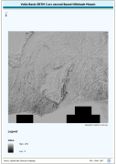
Volta Basin SRTM 3 as Based Hillshade Mosaic. SRTM is Shuttle Radar Topography Mission. The HSHD_MOS grid data layer is comprised of 13201x14401 derivative raster hillshade features derived based on 0.000833_ data originally from SRTM 3as v.2.
-
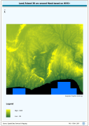
Derivative of the above "Null" SRTM 3-arc second dataset with terrestrial void areas backfilled with SRTM-GTopo30 DEM, 3204 Arc-Grid tiles. Source: FAO
-
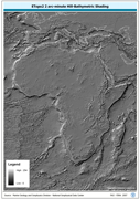
ETOPO2 2 arc-minute Hill-Bathymetric Shading. ETOPO2 is a 2 minute Elevation Topographic DEM including bathymetry. The ETOPO2_HSHD grid data layer is comprised of 5400x10800 derivative raster hillshade | bathymetry features derived based on 0.03333_ data originally from ETOPO2. The layer provides nominal analytical/mapping at 1:12 500 000. Acronyms and Abbreviations: ETOPO2 - A 2 minute Elevation Topographic DEM including bathymetry; DEM - Digital Elevation Model.
-
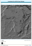
Grid based hillshade of consolidated 30 as SRTM-ETopo2 DEM. SRTM is Shuttle Radar Topography Mission; DEM is Digital Elevation Model; ETOPO2 is a 2 minute Elevation Topographic DEM including bathymetry.. The HSHDBATH grid data layer is comprised of 10800x11400 derivative raster hillshade features derived based on 0.00833_ data originally from SRTM 30as v.2.
-
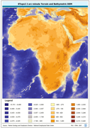
ETOPO2 2 arc-minute Terrain and Bathymetric DEM. The ETOPO2 grid data layer is comprised of 5400x10800 derivative raster bathymetry features derived based on 0.03333_ data originally from ETOPO2. Acronyms and Abbreviations: ETOPO2 - A 2 minute Elevation Topographic DEM including bathymetry DEM - Digital Elevation Model
-

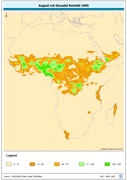
August 1st-Decadal Rainfall 1995. The AUG1_95 grid data layer is comprised of 1152x1152 derivative raster precipitation features derived based on 8 kilometers data originally from EDC. 2nd and 3rd Decadal Rainfall from July to December is also available for download. Acronyms and Abbreviations: EDC - USGS EROS (Earth Resources Observation Systems) Data Center
-
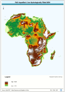
WRIA_DEM: Hydrologically filled GTopo30 DEM with the main stems of cartographic rivers "burned-in" for irrigation analysis. GT30/GTopo30 is Global Topographic 30 arc second DEM database, nominal 1km postings; DEM is Digital Elevation Model. The WRIALAEA grid data layer is comprised of 9194x8736 derivative raster hydrologically filled dem features derived based on 1 kilometer data originally from FAO.
-
Volta Basin SRTM 3 as Based DEM Mosaic. SRTM is Shuttle Radar Topography Mission; DEM is Digital Elevation Model. The DEM_MOS grid data layer is comprised of 13201x14401 derivative raster digital elevation model features derived based on 0.000833_ data originally from SRTM 3as v.2.
-
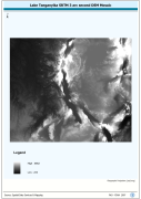
Lake Tanganyika SRTM 3 as DEM Mosaic. The DEM_MOS grid data layer is comprised of 14401x16801 derivative raster digital elevation model features derived based on 0.000833_ data originally from SRTM. The layer provides nominal analytical/mapping at 1:250 000. Acronyms and Abbreviations: SRTM - Shuttle Radar Topography Mission DEM - Digital Elevation Model
-
April 1st-Decadal Rainfall 1996. The APR1_95 grid data layer is comprised of 1152x1152 derivative raster precipitation features derived based on 8 kilometers data originally from EDC. 2nd and 3rd Decadal Rainfall from January to December is also available for download. Acronyms and Abbreviations: EDC - USGS EROS (Earth Resources Observation Systems) Data Center